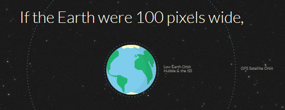
This great website provides a really cool illustration of the distance between Earth and Mars, to scale.
You get to check out the distance of GPS satellite orbits and the moon as well. One thing that the illustration doesn’t mention, however, is that the shortest point between the Earth and Mars isn’t a realistic metric. Because the travel time takes so long (months), you can’t aim for Mars where it is at the time of launch. You have to aim for where it will be when you get there, which of course depends on the route you take. I can’t quite wrap my head around what a “shortest route” would look like, and that’s why I think I need to study some orbital mechanics before I write much more science fiction.
Anyway, enough orbital mechanics talk. Go watch the cool visualization!
On a smaller scale, if you earned the shotgun merit badge it is similar in concept to leading the target. Effectively you have to calculate the speed and trajectory to determine it’s path at a given time, that given time being the amount of time it takes to get there. It would look at first like you’re aiming for nothing.